University Communications and Marketing
College students elevate Billings' profile for Google Earth
April 25, 2008
Contacts:
Tim Urbaniak, Drafting and Design, 247-3050
Dan Carter, University Relations, 657-2269
MSU BILLINGS NEWS SERVICES — Sometime this summer, Billings will have an elevated profile on Google Earth… literally.
And it will all be thanks to a group of students from Montana State University Billings.
The work by 14 students in the drafting and design technology program at the MSU Billings College of Technology will add more than a dozen new three-dimensional views of the city in Google Earth. They will include the various classroom buildings, structures and residence halls at MSU Billings on both the main campus at the West End College of Technology.
Google Earth is a computer tool that allows users to “fly” from place to place on Earth to view satellite imagery, maps, terrain and even three-dimensional buildings rendered by specific computer software programs. The visuals are from satellite imagery captured during various passes of the Earth. After you swoop in from outer space to a specific city, or GPS coordinates, users can pass into and out of areas as if in a high-tech helicopter.
Some cities, like San Francisco or New York, for example, have complete 3-D views of the metropolitan areas contributed by architects or specialists. Other places, like Billings, have great aerial views of the streets and landmarks, but any 3-D perspectives are limited.
Here, you can swoop by the Wells Fargo building in Downtown Billings, the west bleachers at Daylis Stadium or Broadwater Elementary School, but that’s about it.
 As a fourth-semester final project in Tim Urbaniak’s two-year drafting and design
technology program, a team of five students were asked to coordinate to a project
that would raise the profile of Billings on Google Earth. They decided they would
use the multiple buildings of the university.
As a fourth-semester final project in Tim Urbaniak’s two-year drafting and design
technology program, a team of five students were asked to coordinate to a project
that would raise the profile of Billings on Google Earth. They decided they would
use the multiple buildings of the university.
The team leaders — Eric Schulz, Dane Bekkedahl, Casey Carter, Shaun Newell and Cory Hess — started the work in January when the spring semester began. They gathered structural information from blueprints at the university took photos of the buildings and assigned tasks to the nine other students in their class. Each student was responsible for designing and “building” a different portion of the university before forwarding it on to the team leaders for final rendering using SketchUp software.
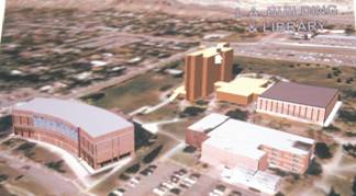
That final step allowed the students to place the three-dimensional buildings they had done at specific locations on Google Earth. So the eight-story Liberal Arts Building — the tallest building on campus — actually rises six levels above the library next door instead of appearing as its architectural equal as it does now.
This week, the students presented the final project and report to university officials. A total of 17 building sections on two campuses were completed and will be submitted to Google Earth for review and inclusion to its popular package. From the bright red parking garage to the rustic brick tones of the residence halls to the white dome of the tennis bubble, the MSU Billings structures stand out against the sandstone Rimrocks. The 14 students put in a combined 346 hours getting the project completed.
“It was a lot of fun,” said Bekkedahl. “It was a great project to work on.”
“It will be cool to have it online and show people what we did,” said Newell.
Carter said the best aspect of the project was learning a new practical application that can be put to use when they find jobs after graduation in May.
A satisfied grin on his face and a poster of the project in front of him, Urbaniak said the project not only showcased the students’ technical skills, but allowed them to take a leadership role in the final development.
“This group headed up the project and they were working in a group dynamic,” he said. “There came to be an element of peer review and peer interaction. They’ll be doing that every day here pretty soon.”
Eakle Barfield, the director of facility services at MSU Billings who contributed funding to buy the software for the project, said he was impressed with the quality of the work by the students. He also said he will likely incorporate the project into an interactive way-finding system for university guests and students.
As a state-of-the project, the students will also enter it in a “SketchUp Your Campus” competition against 300 other colleges and universities from around the world. If they win, by June each of the team leaders could be proud owners of new iPods and Wii systems.
If not, by June they know that they put Billings on the map. Literally.
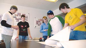
MSU Billings College of Technology drafting and design technology students review plans of different university buildings to get a sense of the structural development. The five students led a project to graphically develop three-dimensional views of structures at MSU Billings for inclusion on Google Earth.